

GROUNDWATER MANAGEMENT ASSOCIATES, INC.
The Groundwater Experts
Featured Project
Hydrostratigraphic Framework of Onslow County, North Carolina
Coastal North Carolina faces significant challenges in the cooperative and sustainable management of the limited groundwater resources. Onslow County has three major water providers that supply the bulk of potable water; the City of Jacksonville (COJ), the Onslow Water and Sewer Authority (ONWASA), and the Marine Corps Base at Camp Lejeune (MCBCL). Groundwater is the sole source of water used by these providers to meet demands, but NC’s Central Coastal Plain Capacity Use Area (CCPCUA) rules restrict withdrawals from the historically-overpumped Cretaceous Aquifer System. Onslow County’s water providers have complied with CCPUA restrictions by increasing reliance on unrestricted aquifers, including the Castle Hayne Aquifer System, Beaufort Aquifer, and Peedee Aquifer.
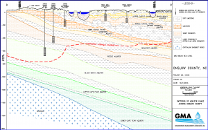
Patterns of aquifer use vary across the county
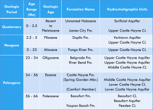
Groundwater Management Associates, Inc. (GMA) conducted a comprehensive analysis of the hydrostratigraphic framework of the groundwater system in Onslow County. The first phase of the study included gathering, compiling, evaluating, and synthesizing field and drilling data, geophysical logs, aquifer test data, and water-quality data from almost 400 wells, borings, and surface exposures. We then interpreted and correlated the elevations of each aquifer, and we mapped the spatial distribution, hydraulic properties, and water quality of each aquifer. Multiple hydrostratigraphic cross sections were prepared to illustrate the seaward-thickening sedimentary aquifer systems that overlie crystalline bedrock.
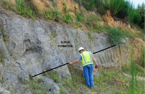
Surface and offshore data were important!
One significant result of GMA’s synthesis is the characterization and spatial delineation of three distinct aquifers comprising the Castle Hayne Aquifer System (CHAS); the Upper Castle Hayne (River Bend) Aquifer, the Middle Castle Hayne (Spring Garden) Aquifer, and the Lower Castle Hayne (Comfort) Aquifer. We recognized specific patterns of use of these three aquifers across Onslow County, and each aquifer has significant differences in yield potential and water quality.
GMA’s refined hydrostratigraphy for the CHAS is being used during the planning and construction of a regional monitoring-well network that is intended to facilitate cooperative monitoring and resource management by the COJ, the ONWASA, and the MCBCL. Our hydrostratigraphic framework study will be refined and updated using the results of the drilling and construction of the monitoring-well network commencing in 2015.
Our proposed hydrostratigraphy of Onslow County